Difference between revisions of "Laurel Highlands Hiking Trail"
Jump to navigation
Jump to search
(Add full 'hiking trail' infobox, copy in data from PJ's edit. Add photo caption. Add abbreviation w/ source.) |
(add trailheads + highest pt) |
||
| Line 1: | Line 1: | ||
{{Infobox hiking trail | {{Infobox hiking trail | ||
| name = Laurel Highlands Hiking Trail | | name = Laurel Highlands Hiking Trail | ||
| − | | photo = Laurel_Highlands_Hiking_Trail_-_panoramio.jpg | + | | photo = Laurel_Highlands_Hiking_Trail_-_panoramio.jpg |
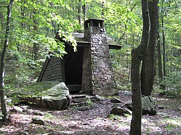
| − | | caption = A shelter on the LHHT | + | | caption = A shelter on the LHHT |
| abbreviated_name = LHHT<ref>https://www.nps.gov/pohe/planyourvisit/laurel-highlands_end-to-end.htm</ref> | | abbreviated_name = LHHT<ref>https://www.nps.gov/pohe/planyourvisit/laurel-highlands_end-to-end.htm</ref> | ||
| − | | location = | + | | location = Ohiopyle, PA, USA |
| − | | length = {{convert|112.6|km|mi|0|abbr=on}} | + | | length = {{convert|112.6|km|mi|0|abbr=on}} |
| − | |||
| − | |||
| − | |||
| − | |||
| − | |||
| − | |||
| − | |||
| − | |||
| trail_agency = ? | | trail_agency = ? | ||
| − | | trailheads = | + | | trailheads = Ohiopyle State Park - 0 mi. <br/> PA Route 653 - 18.8 mi. <br/> PA Route 31 - 30.6 mi. <br/> US Route 30 - 45.8 mi. <br/> PA Route 271 - 56.9 mi. <br/> PA Route 56 - 70 mi.<ref>https://www.golaurelhighlands.com/blog/post/faqs-of-the-laurel-highlands-hiking-trail/#plugins_assets_images_60d22ca05d9d6808f46f57d0</ref> |
| use = Hiking | | use = Hiking | ||
| elev_gain_and_loss = ?<!-- {{convert|22000|ft|m|-2}} gain approximately<ref name="Filley"/> --> | | elev_gain_and_loss = ?<!-- {{convert|22000|ft|m|-2}} gain approximately<ref name="Filley"/> --> | ||
| − | | highest = | + | | highest = Mile 27 - {{convert|2961|ft|m|-1}} <ref>https://www.golaurelhighlands.com/outdoors/parks/state/laurel-highlands-hiking-trail/</ref> |
| − | |||
| − | |||
| − | |||
| − | |||
| − | |||
| − | |||
| − | |||
| − | |||
| − | |||
| − | |||
| lowest = ?<!-- Ipsut Creek Campground {{convert|2320|ft|m|-1}}<ref name="Filley"/> --> | | lowest = ?<!-- Ipsut Creek Campground {{convert|2320|ft|m|-1}}<ref name="Filley"/> --> | ||
| direction = ? <!--Nobo, Sobo...--> | | direction = ? <!--Nobo, Sobo...--> | ||
Revision as of 20:07, 11 October 2022
| Laurel Highlands Hiking Trail | |
|---|---|
 A shelter on the LHHT | |
| Length | 112.6 km (70 mi) |
| Location | Ohiopyle, PA, USA |
| Trailheads | Ohiopyle State Park - 0 mi. PA Route 653 - 18.8 mi. PA Route 31 - 30.6 mi. US Route 30 - 45.8 mi. PA Route 271 - 56.9 mi. PA Route 56 - 70 mi.[1] |
| Elevation | |
| Elevation gain/loss | ? |
| Highest point | Mile 27 - 2,961 feet (900 m) [2] |
| Lowest point | ? |
| Hiking details | |
| Season | ? |
| Months | ? |
| Website | ? |
| Direction | ? |
| Trail agency | ? |
| Abbreviated name | LHHT[3] |
| This article is a stub. You can help the community by expanding it. |
Contents
Overview
Length:
Standard direction(s) of travel:
Season:
Trail Association: